MONTAŃAS DEL FUEGO (TIMANFAYA)
MONTAŃAS DEL FUEGO (TIMANFAYA)
The site of Montańas del Fuego is actually the Timanfaya National Park, a lunar landscape that you can travel through by bus, and during which you will hear the following narrative:
"The island of Lanzarote, with a surface of 805 Kms2, is of volcanic origin, a result of the magma ejected by countless eruptions from the craters that still cover it; more than one hundred peaks in the shape of cones or mountains. The area that we are now visiting has its main orographic centre in Montańas del Fuego, and it is located in the Midwest part of the island. It has about 200 Kms2 of petrified volcanic matter, spewed by fantastic craters, which originated in the Vega de Timanfaya, and left the surrounding ground covered with lava, ashes and cinder.
There are about thirty main volcanic cones left behind by these unimaginable happenings, and they are a dramatic testimony of the awesome eruption that took place in Lanzarote in the VIII Century. It was one of the most important in the history of the world's volcanic activity, not only for the amount of material ejected, but also for its duration. According to documents written by the priest of Yaiza, the eruption began in September of 1730 and lasted until April 16th.1736.
This eyewitness of the catastrophe, Don Andrés Lorenzo Curbelo, wrote: "On September 1st.1730, between 9 and 10PM, at 11 Kms. from Yaiza, the ground close to Timanfaya suddenly opened up. In the first night a huge mountain grew out of the ground and, from its peak, enormous flames that kept burning for 19 days could be seen" . This was the beginning of the spectacular eruptions that continued for more than five and a half years, with a few periods of abated activity.
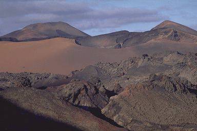
From the natural lookout point of Montańa Rajada, at an altitude of 350 metres, we can see one of the most impressive scenes of the area: an immense sea of lava that covers almost the entire Parque Nacional de Timanafaya and reaches all the way to the sea.
Above this sea of lava, some volcanic peaks reach upwards, crowned by terrifying craters and crossed by large and deep crevasses, caused by the collapsed ceilings of the tunnels that run inside them. The volcanic matter that came out of these craters and cracks filled the depressions of the terrain and gave the ground a noticeable evenness. The red-hot lava, when entering the sea, raised amazing columns of smoke and very possibly added to the surface of the island.
In the historic manuscript written by the priest from Yaiza, the following can be read: "On the 18th of October, three new cracks appeared on the top of Santa Catalina; from them thick clouds of smoke emerged and spread over the whole island, accompanied by great amounts of cinder, sand and ashes that fell to the ground covering a large area."
The explosions that occurred during this eruption, together with the dense smoke and ashes that darkened the island, forced the inhabitants of Yaiza to flee in more than one occasion.
Almost all of the area covered by this lava sea was, before the eruption, one of the most fertile terrains of the region; the old clay fields sustained large crops of cereal. The whole region was sparsely occupied by little hamlets, and there were about 420 dwellings destroyed, among them the villages of Timanfaya, Los Rodeos, Mancha Blanca, Santa Catalina, Mazo, Jarretas, Tingafa, Peńa Palomas, Testeina, La Geria, Macintafe, Mozaga, Guagaro, Masdache and Iguaden. To these we should add small huts in Mareta, Chupaderos, and the chapel of San Juan Bautista, to name a few.
The volcanoes that formed the National Park of Timanfaya spewed, during their peak activity, enormous columns of ashes called pyroclastics; these ashes were spread by the wind covering vast surfaces of the island; mountainsides and craters were buried under the fall-out. A good example of these heavy rains of ashes can be seen at a place called Valle de la Tranquilidad. (Valley of Tranquillity).
The nucleus of this eruption was the massif of Fuego, with the highest peak at 510mts. above sea level.
An interesting point about lava activity can be observed around the base of a major cone; small "parasite volcanoes" and "hornitos"(a universal volcanic term that describes little volcanoes that are formed by the escape of gases from underground melting lava) One of the best areas to see this phenomenon is around the mountain of Timanfaya, the highest of the massif, on its eastern side. Close to it, the Corazoncillo volcano shows its impressive figure; from its uppermost edges, inside jagged walls descend to the bottom of the crater, way below the level of the outside ground.
The last volcanic eruptions in Lanzarote occurred in l824, and they were preceded by several years of earthquake activity of medium intensity, but the principal characteristics of the main eruption were the fluidity of the lava and the enormous columns of smoke from the boiling seawater that came out of the Tinguaton volcano.
The quiet and solitude that permeates this chaotic scene, with its imposing craters and deep caldrons, is overwhelming.
An interesting complement to this impressive scene is the carpet of lichen, of different species and colours, that cover the scoriaceous rocks and stones and, by contrast in this virgin soil, there is a scarcity of superior vegetation like bulrush, which requires a high humidity index in order to exi.
At the end of this dazzling journey we arrive again at the Hilario islet, where we find the amazing presence of geothermic energy that, at 10 metres below the surface, reaches temperatures of 600 degrees centigrade. This site takes its name from one Hilario, a local who used to come to gather fig leaves in order to feed his camel.
In 1974 this area was declared a National Park; its peculiar volcanic characteristics and the beauty of its landscape made such event possible."
There is a document from the Town Hall in Lanzarote and addressed to the President and Judges of the Royal Representatives, dated October 17th, 1730, which is worth mentioning and reads as follows.
"Distinguished Gentlemen: It is with deep feelings of sorrow and distress that this Town Hall informs Your Lordships that due to the explosion of a volcano on the night of the first of this month, and which has spewed fire for nineteen days, we have sustained the loss of houses, water reservoirs and factories; straw stocks, crop fields and trees; all in the towns of Timanfaya, Rodeo, Mancha Blanca, great part of Jaxetas, the best parts of Santa Catalina and its Church (buried). The towns of Peńa Palomas, Jaxetas and most of Geria Alta have been blanketed with sand, causing as much damage as the fire did. At present, another volcano has erupted on the tenth of this month at about five in the afternoon; the distress can be felt on the island for as far as 17 to 22 kilometres; roofs and lands have been damaged and due to the rising sand many plots, public and private alike, have been lost in Vega de Tomare which is the heart of the island, as well as the fertile lowlands of the neighbouring town. This has occurred in Vińon and at the centre of the best places in Texteina, Guagal, Conil, Masdache, Guaticea, Calderetas and San Bartolome and all of their districts. The sand has destroyed the crops and made the fields unfit for cultivation; houses are almost buried, straw storages burned down; the same can be said for Geria Baja, La Vega del Chupadero and part of Uga. Not only the lowlands and fields are buried, as mentioned above, but also the water reservoirs which are unable to store rain water, even if it rains heavily; the cattle fields have run the same fate and, to top it all, birds and rabbits are running around in other fields in order to feed because rats and other critters have invaded the land. All of this pales in comparison with the grief caused by the hopeless cries of men, women and children, ruined by this horrible event. They have been dispossessed of everything and exposed to the elements, looking in the barren land for something to sustain them in these tragic moments. On an occasion such as this, at the gates of Hell, there are no doubts that at the first rains, all the cereal not stored in the sheds will be lost; these sheds are what the islanders use to store their grain and, having most of them been burnt together with the houses, even in remote locations, there are no roofs under which people and grain can be sheltered.
Under these pressing circumstances, the homeless, begging us to let them gather whatever grains they possess and go to another island, have besieged this Town Hall. Their plight has been heard and we have granted their wish in a meeting held on the 15th; and we hereby inform Your Lordships of our efforts with a message to His Excellency, Commander General of these islands, conveying the petition made by the people. We may also add that the tremors in this island continue unabated. This Town Hall has done everything in its power to give encouragement to the many inhabitants terrified by the fires that are still burning and, in order to alleviate this painful state of affairs, has ordered all ships in port to remain anchored, waiting for an answer from Your Lordships and hoping that the situation does not worsen. If the tobacco or grain Administrator intends to take portions of the stored grains, or give some preferential treatment to some interested party, let it be known that the dispossessed will have priority. We hope Your Lordships will speed your orders; the Governor of Arms and the Mayor also request the same from His Excellency, the Commander General. We beg the Heavens to protect Your Lordships, which is the wish of this Town Hall, and as it should be."
It must have been a real hair-raising experience to live in those times on this unstable and brutal land.
When we visit Timanfaya National Park we should think about those horrific days; people scared witless, terrified animals fleeing, towns and houses buried forever under a sea of melting lava...
 Album with old photographs of Montańas del Fuego (Timanfaya)
Album with photographs of Montańas del Fuego (Timanfaya)
2 Album with photographs of Montańas del Fuego (Timanfaya)

Esta pagina ha sido realizada por Sarabel y Chino.
E-Mail: Sarabel y Chino